Concern has grown over the potential impacts that climate change might have on freshwater resources and how these changes might impact aquatic habitat and estuary health. Watershed-scale hydrological modeling studies are important for determining potential stream input changes to individual estuaries, especially in the smaller, less studied ones. Streamflow and stream temperature projections are also crucial for water resources planning and management and can help guide the efforts of tribal scientists, resource managers, and tribal leadership toward more sustainable management of freshwater habitats for ESA listed fish species (such as summer chum, Puget Sound chinook, steelhead, and bull trout) that are particularly vulnerable to a changing climate. To assess locations of particular vulnerability, PNPTC has initiated a multi-phase stream modeling study. The full technical summary reports can be downloaded below.
Phase 1 of the PNPTC numerical modeling project that aims to provide streamflow projections through the end of the 21st century under two climate change scenarios (the moderate warming RCP 4.5 and severe warming RCP 8.5 scenarios) for major streams and their tributaries in the northeastern Olympic Peninsula and Hood Canal. We used the Distributed Hydrology Soil Vegetation Model (DHSVM) to simulate snowpack and streamflow evolution for the Big Beef, Big Quilcene, Chimacum, Dosewallips, Duckabush, Dungeness, Hamma Hamma, Jimmycomelately, Little Anderson, Little Quilcene, Salmon, Seabeck, Snow, Stavis, and Tarboo watersheds. Simulations span from 1950-2099 and provide likely future flow projections at 30-year intervals from 2010-2040, 2041-2070, and 2070-2099.
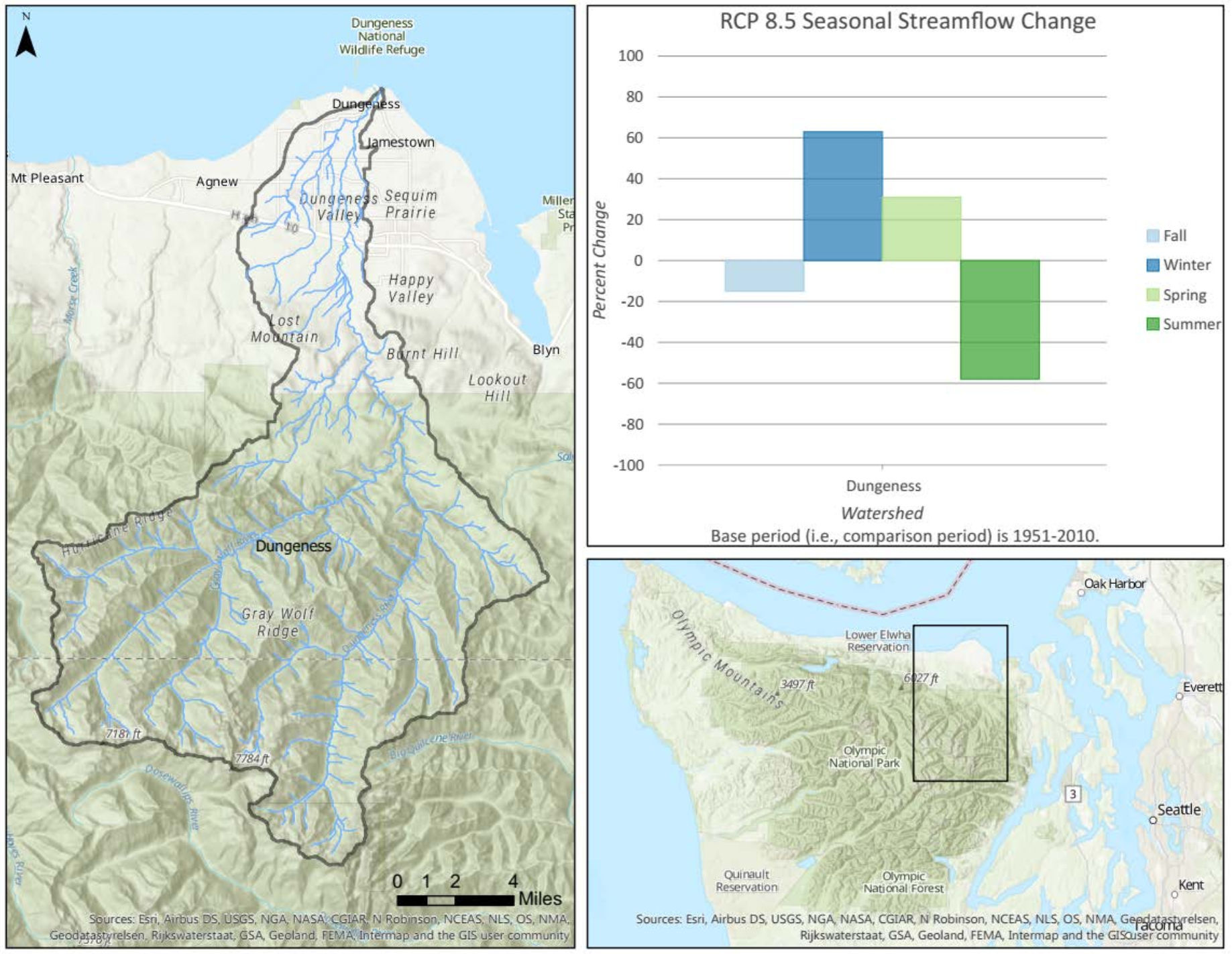
Projections under both scenarios indicate that watersheds with medium to high relief, where snowpack plays an important role in the stream hydrology, are likely to experience a large shift in both timing and magnitude of the annual hydrograph (see figure 1 below for an example from the Dungeness River). A strong linear relationship was found between elevation and projected seasonal (winter and summer) streamflow changes. Low-elevation watersheds are not likely to experience a drastic change in magnitude, but instead will experience moderate winter flow increases and little change in summer flow. In some of the higher-relief areas, however, peak winter flows are projected to nearly double while summer flows are projected to decrease by greater than half as snowpack is diminished. The projected changes in several study area watersheds have the potential to drastically alter fish habitat during the freshwater stages of the anadromous fish life cycle. For example, higher magnitude flows occurring during winter months can result in a greater frequency of egg-scouring events (which harm the eggs) and access to spawning and rearing habitat can be diminished because of drier conditions during the summer months.

Phase 2 expanded the project to include stream water temperature projections. We used the stream temperature River Basin Model (RBM) to simulate stream temperature changes for the same watersheds and time-span as in phase 1. Stream temperatures are expected to increase greatly throughout the Hood Canal and Strait of Juan de Fuca region and are likely to regularly exceed safe migration and spawning temperatures for many fish species by the latter half of the 21st century. The below figure is an example for the low-elevation Tarboo Creek watershed. By the end of the 21st century, the amount of stream habitat that annually exceeds safe temperature thresholds for salmonids is likely to more than double under a moderate warming RCP 4.5 scenario and more than triple for the high warming RCP 8.5 scenario. The projected warming has the potential to greatly reduce the amount of fish habitat available to migrating and spawning salmonids throughout the region.

Phase 3 of the PNPTC stream modeling project is underway, and will incorporate the streamflow and stream temperature results from phases 1 & 2 as part of a detailed study on the impacts of climate change to mid Hood Canal Chinook salmon. This project will highlight the most likely habitat changes for various life stages of this unique and threatened sub-species of salmon. This work is likely to be finished at some point in 2020.
For more information about the PNPTC stream modeling project, see the technical summary reports below or visit our Reports and Publications page for additional project downloads.
- Phase 1: Streamflow Projections (file size is 3 mb)
- Phase 2: Stream Temperature Projections (file size is 6 mb)