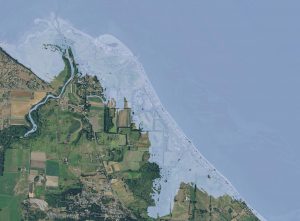
Sea-level rise due to climate change leads to higher coastal water levels, thereby altering ecosystems through increased inundation of estuarine beaches, tidal flats, and inland and freshwater marshes. This, in turn, will increase the vulnerability of critical Tribal resources. To allow resource managers to anticipate such threats it is necessary to map the locations and extent of existing estuarine habitats in our study area and to model the potential changes in quality and geographic extent of these habitats as sea level rises. PNPTC have begun a pilot study to map the locations and extent of existing estuarine habitats and to model the potential changes in quantity and geographic extent of these habitats through the end of the 21st century in the Duckabush, Quilcene, and Snow/Salmon estuaries. These sites were chosen due to their importance as shellfish, salmonid, and bird habitat.
The PNPTC sea level rise modeling project makes use of our estuary habitat base mapping project results and the Sea Level Affecting Marshes Model (SLAMM) to predict the effects of inundation, erosion, and accretion under various sea level rise scenarios. Under a 5-ft sea level rise scenario, much of the present day intertidal habitat is likely to be impaired or lost. These results indicate a large shift in the types of habitat that will be available to culturally and economically important fish and shellfish species in the Puget Sound area.
For more information about this project, see the technical summary report: